Understanding the value of MARACOOS hurricane gliders as they monitor a key oceanographic feature in the Mid-Atlantic Bight
Summer 2026 marked the first hurricane season underwater gliders were formally written into the National Hurricane Operations Plan, an essential piece of the United States hurricane forecasting toolkit. The plan catalogs the interdepartmental coordination surrounding forecasts, warnings, and assessments of tropical and subtropical weather systems.
For decades, hurricane forecasting has relied on aircraft reconnaissance, satellites, and buoy data to better inform and predict hurricane intensity. The addition of underwater gliders recognizes their unique contribution in providing data on water column temperature, salinity, and pressure. These data supply a holistic picture to models allowing for a more realistic ocean simulation and therefore more accurate hurricane intensity forecasts.
For the glider team at MARACOOS, this was a welcome announcement ahead of the team’s 2026 hurricane glider deployment season. The addition of gliders into the operations plan is the result of many years of ongoing seasonal deployments, case studies that demonstrated the value and impact of glider data on forecasting storm intensity, and continued endorsement from researchers across the field that this technology would support weather forecasters as they prepare communities for an incoming storm.
In highlighting regional contributions to hurricane intensity forecast improvements, Dr. Gerhard Kuska, MARACOOS Executive Director, said, “our researchers understood the science of these storms and recognized that the application of this technology would significantly enhance the models and forecasts that ultimately could save countless lives and help protect billions of dollars in property and infrastructure.”
A Look Inside MARACOOS Glider Deployments
MARACOOS hurricane glider deployments are funded and operated by MARACOOS in collaboration with regional partners at Rutgers University (RU), William & Mary’s Virginia Institute of Marine Science (VIMS), the University of Massachusetts-Dartmouth (UMass Dartmouth), the University of Delaware (UD), and Stony Brook University. Together they launch MARACOOS’ seven yearly deployments taking place in the Mid-Atlantic that follow the northern ‘W’ track and those that follow the southern ‘W’ track (Figure 1).
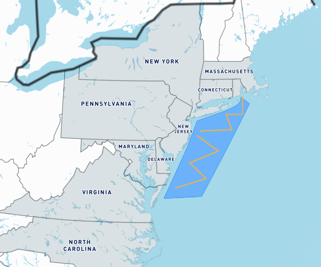
MARACOOS glider deployments follow this track pattern year over year to ensure coverage throughout the northern Mid-Atlantic Bight (MAB) specifically focusing on the Cold Pool, a key oceanographic feature in the Mid-Atlantic Bight. The Cold Pool is a layer of cold water left over from the winter months trapped below the sea surface layer that not only influences tropical storm intensity but serves as a vital component of the ecosystem.
As an approaching tropical storm passes over the Mid-Atlantic Bight, hurricane force winds can churn the frigid water (below 8ºC) up into the warm surface waters (over 28ºC) causing surface temperatures to drop 4ºC to 7ºC. If that mixing happens ahead of the eye of the storm, it reduces the storm’s ability to maintain and grow in strength. Conversely, if a storm’s trajectory and winds push cold water out of the eye’s path, leaving only warm water in place, the storm is likely to continue intensifying as it approaches land. These dynamics help forecasters, community planners, and emergency managers make informed decisions as they prepare their communities for an incoming storm and serve as a core reason for MARACOOS glider deployment tracks.
Glider deployments run during hurricane season from June through November, with each glider spending approximately 30 days in the water before it is retrieved and the next one is launched. This ensures at least one glider is stationed throughout the Mid-Atlantic Bight during hurricane season. While gliders are autonomous and navigate the water column on a preplanned track, they are remotely managed and can be piloted when needed by the MARACOOS partner and their team overseeing their deployment. When a glider surfaces it relays the most recent scientific data and awaits any new instructions from the team before diving—a line of communication that proved critical during the deployment of MARACOOS’ newest glider.
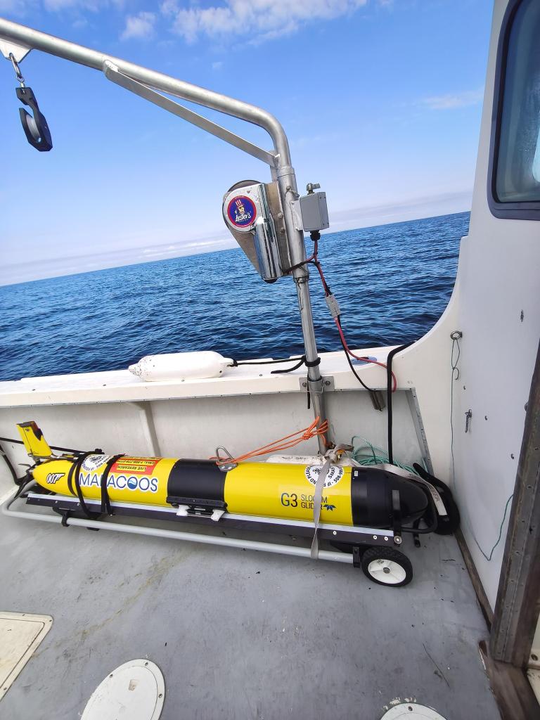


On September 17, UMass Dartmouth Professor and MARACOOS partner Miles Sundermeyer and his team launched the newest member of MARACOOS’ glider fleet, MARACOOS_007, east of Block Island, RI (Figure 2-4) with a set track to follow the northern ‘W.’ In just over a week of launching, MARACOOS_007 and the operation team were met with its first challenge – a nor’easter that lingered in the region. “We were tracking the storm and monitoring the wind, wave and current forecasts,” Dr. Sundermeyer said. “With wind speeds up to 45 kts and waves greater than 20 ft, we tried to keep the glider below the surface, but in order to transmit its position and scientific data it needs to be at the surface to connect to the Iridium satellite communications. There was a strong westward current the glider could not win against. We ultimately had to adjust the first southbound leg of the mission and create a more rounded end to our ‘W’ (Figure 5 & Figure 6).”


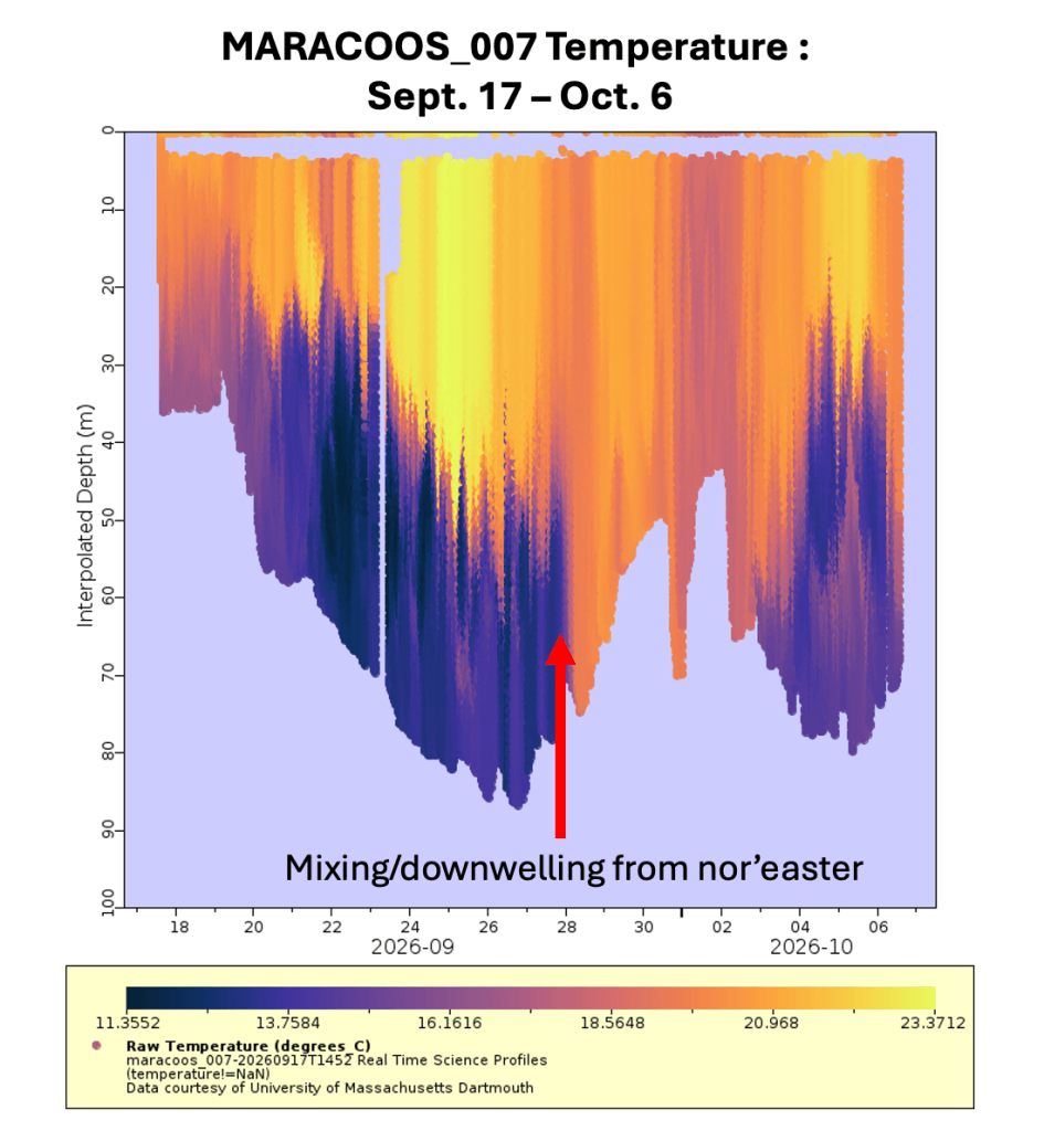
Despite the slight navigational change, MARACOOS_007 was able to record interesting data as the nor’easter sat on or near the shelf from September 25-29 (Figure 7). “With MARACOOS_007 deployed, we captured the surface cooling and deepening thermocline which began on September 25, and complete mixing/downwelling of the entire water column early on the 28th — down to 75 meters,” MARACOOS regional glider coordinator Mike Crowley said.
Dr. Sundermeyer and Crowley are working together alongside their teams at UMass Dartmouth and Rutgers to compare the data from an earlier deployment that followed the same northern ‘W’ track MARACOOS_002 (deployed August 17-September 16) with the data MARACOOS_007 is now collecting post storm. Crowley notes that already sea surface temperatures and temperatures at 75 meters both read 19-20ºC.
Dr. Sundermeyer has also used MARACOOS_007’s mission as a learning opportunity for his Introductory Physical Oceanography course at UMass Dartmouth by providing weekly write ups explaining how they pilot and make decisions and about what to do under different circumstances. Dr. Sundermeyer has been able to provide contrasting data points in write ups from both MARACOOS_002 and MARACOOS_007 (Figure 8-10). It’s a great opportunity for the next generation of ocean scientists to see more about what ocean observing looks like in real time and how ocean and coastal data are being collected.


Figures 8-10: Various data from Dr. Sundermeyers week 2 write-up showing (left to right); Potential temperature transects measured by glider MARACOOS-02 (top, Aug 2026) and MARACOOS-007 (bottom, Sept 2026) during their north-south cross-shelf transect heading south from Block Island, RI; Profiles of potential temperature, salinity, dissolved oxygen, chlorophyll-a, and CDO as measured by glider MARACOOS-007 between Saturday, Sept 26 12:00 h GMT and Monday, Sept 29 00:00 h GMT.
Despite the quieter hurricane activity in the region, MARACOOS’ glider deployments are still providing critical long term data, including how this most recent nor’easter altered the water column. It’s another example of the value of underwater gliders and consistent deployment schedules. As MARACOOS_007 nears the end of its deployment, the team will continue comparing the data collected with that of MARACOOS_002 to build a clearer picture of how storms like this one reshape the ocean off our coast.
In part 2: How El Niño shaped this summer’s hurricane season and ocean conditions in the Mid-Atlantic.
Upcoming Glider Webinar: From Deployment to Data: Exploring the Mid-Atlantic with Gliders
Tuesday, December 8, 2026
11:00 am – 12:00 pm
Join MARACOOS for a behind-the-scenes look at the Mid-Atlantic regional glider program and follow the journey of glider from the time of deployment to near real-time data delivery. Learn more about how underwater hurricane gliders work, what they measure, and the teams responsible for deploying and operating them.
Related Posts
Share this post

